To view this page ensure that Adobe Flash Player version 10.1.0 or greater is installed.
Remote sensing: placing nature at our fingertips
Friday 20 January 2012
Researchers at UC Natural Reserve System locations use sensors to map land, track animals and collect environmental data.
When the crew of Apollo 17 snapped the famous Blue Marble photo of Earth in 1972, they gave humanity its first truly global perspective on the planet we all call home. The image helped spark recognition of Earth as having a finite and fragile environment.
Today, UC scientists continue to examine our familiar world through new lenses. Their views of Earth systems — constructed from data transmitted wirelessly across miles of land or sea — are opening our eyes to hidden levels of environmental complexity.
Many of these researchers choose to base their work within the UC Natural Reserve System. This network of 37 natural areas, which encompasses 750,000 acres across the state, offers protected lands for scientists to pursue their research.
Much of the remote sensing equipment now used to map land, track animals and detect the weather was first used and tested at reserve sites. Conditions at reserve sites — rugged terrain, thick vegetation, lack of electric power — push equipment designs to the limit.
Many reserves are blanketed with sensor networks that put nature at our fingertips. The sensors can collect a continuous stream of information ranging from snowfall levels to videos of wildlife. They allow field researchers to acquire data from their office computers instead of camping for days in remote locations.
LiDAR mapping
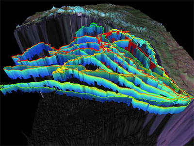
NRS scientists have taken a page from the astronauts’ playbook. They are studying Earth from overhead, with a penetrating twist. A human pilot flying over a wooded ravine can discern the contours of the tree canopy but not the land beneath. To map such forbidding terrain, UC Berkeley's Bill Dietrich, professor of Earth and planetary sciences, uses a laser eye affixed to the plane. Capable of piercing right through leaves and branches, this technology peels back surface features to reveal the underlying topography. (See image at top of page.) The approach produces tremendously accurate maps but also helps scientists model how the landscape formed.
At the NRS’s Angelo Coastal Range, Dietrich uses a technique called LIDAR (Light Detection and Ranging) to create a vegetation-free digital version of the landscape.
In LIDAR, an airplane directs laser pulses toward the ground; the time the light takes to bounce back indicates an object’s distance from the aircraft. The laser light can filter past leaves and branches to reach the ground. The result is terrain maps detailed enough to reveal individual trees as well as how the landscape evolved.
Seal tagging
Remote sensing also enables scientists to get information impossible to collect in any other way. When UC Santa Cruz biology professor Dan Costa first began studying elephant seals, “We knew where they bred and reproduced, because that happened onshore. But that was it,” Costa says.
Since then, equipment first used at Año Nuevo Island Reserve has helped Costa trace the migrations of seals and albatrosses, but also map an ice-covered section of Antarctic Ocean floor. “We know so little about these animals that every opportunity to put tags on them, to gather information about them, is an incredible opportunity.”
This female northern elephant seal came ashore to give birth and breed at the NRS’s Año Nuevo Island Reserve. There, Costa and colleagues mounted a satellite GPS tag on her head to track her ocean migrations and foraging habits. The tags also measure temperature, salinity, and dive depth. The accelerometer on her jaw records how and when she bites at prey as she hunts. The instruments fall off after a year, when the seals molt.
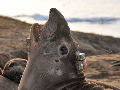
In addition to a satellite GPS tag, seals wear a tubelike device on their backs that detects acoustic pingers mounted on salmon and other fish located within a kilometer.
Below are ocean temperature profiles generated by seven elephant seals traveling across the North Pacific. Oceanographers are using such pinniped tag data to improve the accuracy of ocean condition models and map the ocean floor in greater detail.
Very large ecological array
UC Berkeley biology professor Todd Dawson and digital ecologist Michael Hamilton are developing a wireless array that can gather and relay environmental data from sensor nodes, such as the one below, installed across an entire watershed. The sensors gather information such as soil moisture, temperature, humidity, wind speed, and solar radiation. The network is being installed at the NRS’s Blue Oak Ranch Reserve, where Hamilton is reserve director.
Nighttime temperatures can vary by as much as 30 degrees Fahrenheit across the Blue Oak Ranch Reserve. Such data can help scientists learn how soil moisture, solar irradiance, rainfall and other physical conditions affect plant growth, sap flow, flowering and other ecological phenomena.
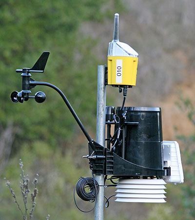
Photo credits:
LiDAR image: Courtesy of National Center for Earth-Surface Dynamics
Seal tagging: Courtesy of Daniel Costa
Ecological array: Michael Hamilton